Many centuries before the Europeans arrived in this region in the 1700s, before there was an area known as York County, it was the unsurrendered and unceded traditional lands of the Wolastoqey/Walastekwey, Mi’kmaq, and Passamaquoddy peoples- and remains so today. These First Nation people share a rich history and stewardship of this land reaching back many thousands of years, utilizing the lands for hunting and fishing, and its extensive waterways that served as communication, commercial, and social assembly thoroughfares. For more information consult Indigenous History Resources.
Beginning in 1784, non-indigenous peoples from the newly formed United States of America and Europe began establishing settlements starting with the Loyalists following the end of the American Revolutionary War. Setttlers from Ireland and Scotland followed among others.
This area is contained in York County, established in 1785, named after King George lll’s (1763-1827) second son who became the Duke of York. Today, it is called Harvey Rural Community.
Within its boundaries were many individual settlements established mostly by people from the British Isles and former American colonies. From farming and mills in the early 19th century to railway stations in the later part of the century, each settlement has its own story. Many of these place names are still refered to today as home.
Here is a comprehensive list of place names in Harvey Rural Community. Some are the names of original settlements, others of communities, and still others of municipal districts.
- Acton
- Black Settlement at Lake George
- Blaney Ridge
- Brockway
- Burden
- Caledonia
- Christie Ridge
- Coburn
- Cork
- Donnelly Settlement
- Ensor
- Frog Lake
- Gass
- Harvey Rural Community
- Harvey Settlement
- Harvey Station and Village of Harvey
- Hurley Corner
- Kings Landing
- Kitchen Settlement
- Lake George
- Little Settlement
- Longs Creek
- Magaguadavic
- Magundy
- Manners Sutton
- Newmarket
- Pokiok
- Prince William
- Lower Prince William
- Upper Prince William
- Prince William Station
- Roach
- Smithfield
- South Tweedside
- Tomaston Corner
- Tweedside
- Warren
- Wilmot
- Whitehead
- Wooler Settlement
- York Mills
Integrated into settlements were Black settlers, some of whom were enslaved prior to their arrival in New Brunswick. These people in tandem with the histories of the settlements will eventually be written about on this website.
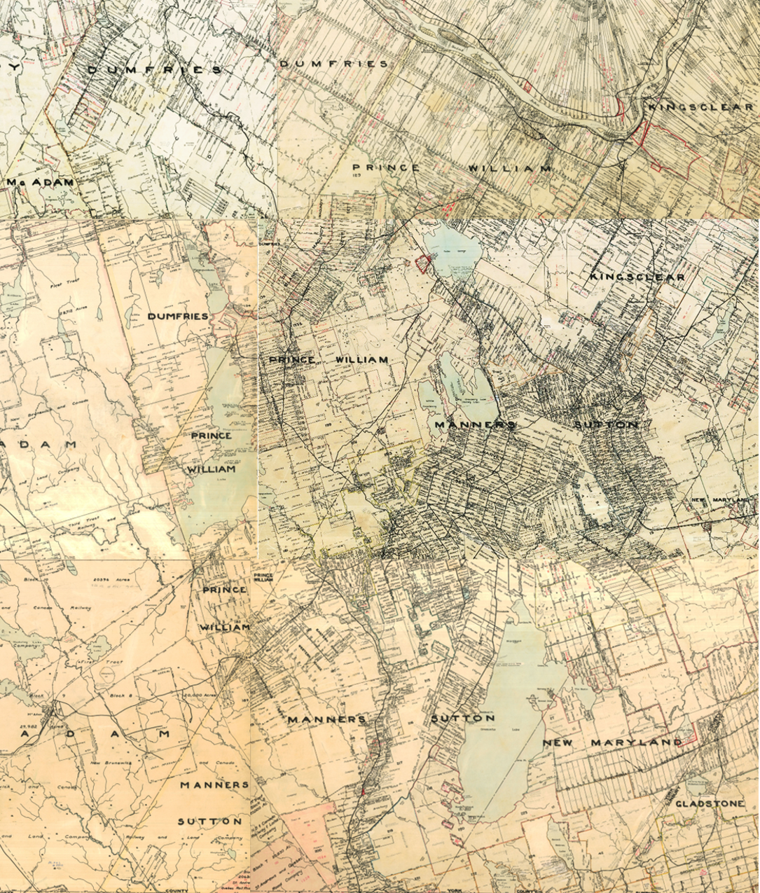
The map below shows the original land grants within the boundaries and beyond of Harvey Rural Community. Such maps are called cadastral maps. The dates of the grants depend on when the grant was approved by the authorities. For example, one grant in Wilmot may have been approved on a different date than the one adjacent. Some properties were granted in the late 1700s while others in the 1800s.
Source: Provincial Archives of New Brunswick, Harvey and Area 1968 to 1992.